Sunday, August 31, 2008

DEAD SEA SCROLLS WILL BE ON THE INTERNET

Israel to Display the Dead Sea Scrolls on the Internet - NYTimes.com

JERUSALEM — In a crowded laboratory painted in gray and cooled like a cave, half a dozen specialists embarked this week on a historic undertaking: digitally photographing every one of the thousands of fragments of the Dead Sea Scrolls with the aim of making the entire file — among the most sought-after and examined documents on earth — available to all on the Internet.

Equipped with high-powered cameras with resolution and clarity many times greater than those of conventional models, and with lights that emit neither heat nor ultraviolet rays, the scientists and technicians are uncovering previously illegible sections and letters of the scrolls, discoveries that could have significant scholarly impact.

The 2,000-year-old scrolls, found in the late 1940s in caves near the Dead Sea east of Jerusalem, contain the earliest known copies of every book of the Hebrew Bible (missing only the Book of Esther), as well as apocryphal texts and descriptions of rituals of a Jewish sect at the time of Jesus. The texts, most of them on parchment but some on papyrus, date from the third century B.C. to the first century A.D.

Only a handful of the scrolls exist in large pieces, with several on permanent exhibit at the Israel Museum here in its dimly lighted Shrine of the Book. Most of what was found is separated into 15,000 fragments that make up about 900 documents, fueling a longstanding debate on how to order the fragments as well as the origin and meaning of what is written on them.

Scholars continually ask the Israel Antiquities Authority, the custodian of the scrolls, for access to them, and museums around the world seek to display them. Next month, the Jewish Museum of New York will begin an exhibition of six of the scrolls.

The entire collection was photographed only once before — in the 1950s using infrared — and those photographs are stored in a climate-controlled room because they show things already lost from some of the scrolls. The old infrared pictures will also be scanned in the new digital effort.

“The project began as a conservation necessity,” explained Pnina Shor, head of the conservation department of the Israel AntiquitiesAuthority. “We wanted to monitor the deterioration of the scrolls and realized we needed to take precise photographs to watch the process. That’s when we decided to do a comprehensive set of photos, both in color and infrared, to monitor selectively what is happening. We realized then that we could make the entire set of pictures available online to everyone, meaning that anyone will be able to see the scrolls in the kind of detail that no one has until now.”

The process will probably take one to two years — more before it is available online — and is being led by Greg Bearman, who retired from the NASA Jet Propulsion Laboratory. Data collection is directed by Simon Tanner of Kings College London.

Once this project is completed, he said with wonder, “every undergraduate will be able to have a detailed look at them from numerous angles.”


Israel: 3,000-year-old apiary discovered

Scientists have unearthed the remains of a large-scale beekeeping operation at a nearly 3,000-year-old Israeli site.

Excavations in northern Israel at a huge earthen mound called Tel Rehov revealed the Iron Age settlement. From 2005 to 2007, workers at Tel Rehov uncovered the oldest known remnants of human-made beehives, excavation director Amihai Mazar and colleagues report. No evidence of beekeeping has emerged at any other archaeological sites in the Middle East or surrounding regions. "The discovery of an industrial apiary at Tel Rehov constitutes a unique and extraordinary discovery that revolutionizes our knowledge of this economic endeavor,
particularly in ancient Israel," says Mazar, an archaeologist at the Hebrew University of Jerusalem.

The earliest known depiction of beekeeping appears on a carving from an Egyptian
temple that dates to 4,500 years ago. It shows men collecting honeycombs from cylindrical containers, pouring honey into jars and possibly separating honey from beeswax. Beehives portrayed in ancient Egyptian art resemble those found at Tel Rehov, as well as hives used
today by traditional Mediterranean and Middle Eastern groups, says entomologist Gene Kritsky of the College of Mount St. Joseph in Cincinnati. "Tel Rehov is so important because it contains a full apiary, demonstrating that this was a large-scale operation," Kritsky says.

Mazar's team has so far uncovered 25 cylindrical containers for bees in a structure that is centrally located in the ancient city at Tel Rehov. High brick walls surrounded the apiary. Beehives sat in three parallel rows, each containing at least three tiers. Each beehive measured 80 centimeters long and about 40 centimeters wide. In the best-preserved beehives, one end contains a small hole for bees to enter and exit. A removable lid with a handle covers the other end.

A violent fire in ancient times caused walls surrounding the hives to collapse and destroy many of the bee containers. Radiocarbon measures of burned grain from the apiary floor and nearby structures provided an age estimate for the finds. Mazar estimates that the ancient apiary contained at least 75 and perhaps as many as 200 beehives. The facility held more than 1 million bees and had a potential annual yield of 500 kilograms of honey and 70 kilograms of beeswax, Mazar says. Only a strong central authority could have established and maintained a large apiary in the center of town, Mazar notes.

The apiary apparently hosted ceremonies intended to spur honey production and ensure the operation's success. Ritual finds near the hives include a four-horned clay altar that features carved figures of two female goddesses flanking an incised tree.

Source: ScienceNews (29 August 2008)
http://tinyurl.com/6e4cl5

Stonehenge -- new facts

Since I am co-author with Cambridge don Caroline Malone on a Oxford U Press book for young people called Stonehenge (available from Amazon), I like to include new facts since we wrote the book a few years ago. I find the following quite fascinating:

A 20ft-high palisade hid Stonehenge 5,000 years ago

Tourists who complain about the fence put up around Stonehenge in the Seventies should spare a thought for their Neolithic ancestors... they couldn't even see the site because of a huge wooden barrier.

Archaeologists have found traces of the 20ft-high timber fence that snaked almost two miles across Salisbury Plain and hid sacred ceremonies from unworthy locals more than 5,000 years ago. Now trenches have been dug along the line researchers believe the palisade took as it stretched from the east of the ancient stone circle, past the Heel Stone, to the west before heading south.

Experts believe that the time and energy taken to construct such a barrier, which has no other practical or defensive use, meant that it was designed to hide religious ceremonies from prying eyes. Dr Josh Pollard, of Bristol University, who is co-director of the dig, said: "The construction must have taken a lot of manpower. The palisade is an open structure which would not have been defensive and was too high to be practical for controlling livestock. It certainly wasn't for
hunting herded animals and so, like everything else in this ceremonial landscape, we have to believe it must have had a religious significance. The most plausible explanation is that it was built at huge cost to the community to screen the environs of Stonehenge from view. Basically, we think it was to keep the lower classes from seeing what exactly their rulers and the priestly class were doing."

Source: Daily Mail (30 August 2008)
http://tinyurl.com/6oxcos

Sunday, August 24, 2008

ROCK ART LINKS IN ENGLAND

Sorry about the ad-wouldn't delete!!


England's Rock Art

Scattered across northern Britain are obscure and mysterious symbols carved into stone outcrops on moors and uplands. They were made by the people of the Neolithic and Early Bronze Age, between 6,000 and 3,000 years ago.


This new site explains what is known about them and where to see them, and suggests short walks to some of the best. The most famous are at Roughting Linn in Northumberland, where there is also a picturesque waterfall.

Cresswell Crags

The oldest known example of figurative art in Britain is a cartoon-like drawing of a horse's head engraved scratchily into a piece of bone, thought to date to about 8,500 BC. It was found at these caves in Derbyshire, which were used as homes or shelters by hunter-gatherers shortly after the end of the last ice age and are now open to visitors.

Cresswell cave art

advertisement

In just the past five years, a number of stone-age paintings and carvings have been discovered in the caves at Cresswell, particularly on the ceilings. Nobody had previously imagined that Britain had any stone age art to rival the cave paintings of France and Spain. For more information, see news.bbc.co.uk, search for "Creswell Crags" and read the stories from BBC Notts dated July 13, 2004 and BBC Bristol dated April 25, 2005.

Cheddar cave art

Although it is known that the caves in Cheddar Gorge were inhabited, the caves flood frequently and have been damaged by Victorian excavations, so there was little hope of finding paintings there. Recently, however, someone spotted what may or may not be a carving of a mammoth (search for "Cheddar Gorge" and read the story entitled "Rare Ice Age rock art found in Cheddar Gorge"). For visits to the caves, see cheddarcaves.co.uk.

Gavrinis

The same people of the Late Neolithic and Early Bronze Age who created the enigmatic rock art of Northern England also produced the dramatic tombs, like tunnels into the underworld, which are our most intriguing ancient monuments. Many have carvings on their walls, and the best examples are concentrated on the western, Atlantic fringes of Northen Europe: Barclodiad y Gawres and Bryn Celli Ddu in Anglesey, North Wales (www.cadw.wales.gov.uk); Newgrange, Knowth and Loughcrew in Ireland (www.heritageireland.ie); and the extraordinary Gavrinis in Brittany, France (click "By periods" and choose "Megaliths in Morbihan").

Kilmartin Glen

Scotland's premier location for anyone interested in ancient art is a small valley on the west coast, west of Inverary and south of Oban. Grouped together in just a few square miles are "cup and ring" markings on rock outcrops; tombs with depictions of bronze axes carved into their walls; and, to bring us into the Christian era, a collection of carved grave slabs from the 800s and 900s.

Uffington White Horse

Carved on a Berkshire hillside just beneath the ancient road called the Rigeway, the Uffington horse was recently dated at about 3,000 years old - far older than anyone had imagined possible. It also appears to be in pretty much its original form. (Under "Conservation, heritage & learning" click "Countryside & environment" and choose "Archaeology", then "Places to visit".)

Small things

An enormous wealth of small examples of the decorative arts - Iron Age cloak pins, Roman brooches, Saxon pendants - has been found over the years, but most of it is squirrelled away in dusty archives in the back rooms of museums. The digital era means that some of this stuff can be brought back into the light, a good example being the National Education Network's Gallery website. Try, for example, the "Norfolk Heritage Explorer" (click "Culture and Heritage" and see the second page), which features lots of small finds from the county. Also see the website of finds made by metal detectorists at detego.co.uk.

Sutton Hoo ship burial

The outstanding works of art of pre-Christian Britain are the treasures found in the grave of an East Anglian king who was buried in his ship under a mound of earth at a location on the Suffolk coast in about AD600. Visitors to the British Museum, where the treasures are kept, should head straight for them: the most finely wrought is an enamelled purse, but what really catches the imagination is the replica sword, light dancing on the intricate patterns of its blade (click "Explore" and "Online tours", then choose "Britain" and "Our Top Ten British Treasures").

Pictish symbol stones

Carved stones and stone crosses of the early Christian era are found through the British Isles, the obvious examples being the "Celtic crosses" of Ireland, which were much copied as gravestones in Victorian times. In eastern Scotland, however, carved stones had a distinct character, being decorated with peculiar symbols - a comb, a mirror, the "crescent and z-rod" - as well as figures of people and animals. The Aberdeenshire council website has a useful introduction (click "Site Directory" and under "Leisure, Culture and Tourism" click "Archaeology" then "Sites to Visit"), but the best stones are found a little further south, around Dundee, at Aberlemno and Meigle (see www.historic-scotland.gov.uk).

YORKSHIRE ARCHAEOLOGY VISIBLE FROM FIRES

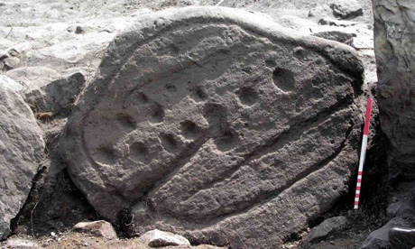
Carved stones found on Fylingdales Moor in North Yorkshire

Carved stones found on Fylingdales Moor in North Yorkshire

A catastrophic fire which "skinned" a precious moorland to its rocky bones has unexpectedly revealed some of the most important prehistoric archaeology found in Britain. The uncontrolled six-day blaze on Fylingdales Moor in North Yorkshire has exposed a lost landscape dating back 3,000 years which is now to be made accessible to the public by English Heritage.

Unique rock art and unprecedentedly clear bronze age field boundaries have emerged from the soot and cinders which were all that was left of two-and-a-half square miles of the North York Moors national park when fire crews and heavy rain finally swamped the area in September 2003. The intense heat destroyed the entire blanket of peat which had accumulated over the area, close to the North Sea coast, since farmers abandoned it for unknown reasons in around 1000BC.

"We have always known that this part of the world is very rich in prehistoric remains," said Graham Lee, senior archaeological conservation officer for the national park. "But the sheer number of new finds exposed by the fire is the most exciting development in archaeology in my experience." The rock art list for the site, part of a vast moor also used by the RAF's Fylingdales satellite tracking and early warning station, has grown to almost three times its previous size, with more than 100 sets of mysterious lines, cups and circles discovered since the fire.

"One of the very rare features exposed by the removal of the entire plant and soil covering is a set of defined borders to the areas cultivated in the bronze age," said Lee.The North York Moors form one of Britain's most important prehistoric sites, with the wild, rolling uplands the equivalent of Leeds or Manchester in their day. In contrast to most of the rest of the country, their population had its heyday in the second century BC, and has since dwindled to today's scattering of neat villages which largely depend on tourism.

"The fire was environmentally disastrous," said Lee, whose colleagues joined landowners after the fire in reseeding the heather. "But it gave us access to a landscape which we could never have reached otherwise, on such a scale. No archaeologist has the means to dig out an area like this. What we have found as a result has altered perceptions of the period. It also raises questions about the scale of what else lies hidden over the rest of the North York Moors."

Finds include stone age flint tools and drainage runnels and trackways from the 18th century alum industry, which used shiploads of urine from London to break down shale and produce the chemical for dyes and other ground-breaking uses in the Industrial Revolution.

The wealth of the Fylingdales finds will now be collated with a £26,000 publication grant from English Heritage, following a local exhibition of the principal discoveries. "Everyone had to work very rapidly, because the protective cover had vanished," said Lee. English Heritage's project officer for Fylingdales, David Went, said the fire had "opened up a whole new chapter in our understanding of the moor".

Sunday, August 17, 2008

YUCATAN PENINSULA REVELS UNDERGROUND CAVES THAT MAYANS BELIEVE WAS ENTRY TO UNDERWORLD

Fri Aug 15, 2008

By Miguel Angel Gutierrez

Mexican archaeologists have discovered a maze of stone temples in underground caves, some submerged in water and containing human bones, which ancient Mayans believed was a portal where dead souls entered the underworld.

Clad in scuba gear and edging through narrow tunnels, researchers discovered the stone ruins of eleven sacred temples and what could be the remains of human sacrifices at the site in the Yucatan Peninsula. Achaeologists say Mayans believed the underground complex of water-filled caves leading into dry chambers -- including an underground road stretching some 330 feet -- was the path to a mythical underworld, known as Xibalba.

According to an ancient Mayan scripture, the Popol Vuh, the route was filled with obstacles, including rivers filled with scorpions, blood and pus and houses shrouded in darkness or swarming with shrieking bats, Guillermo de Anda, one of the lead investigators at the site, said on Thursday. The souls of the dead followed a mythical dog who could see at night, de Anda said.

Excavations over the past five months in the Yucatan caves revealed stone carvings and pottery left for the dead.

Different Mayan groups who inhabited southern Mexico and northern Guatemala and Belize had their own entrances to the underworld which archaeologists have discovered at other sites, almost always in cave systems buried deep in the jungle.

Sahara Cemetery shows a Green Sahara 10,000 years ago

Go to the site and watch the video for more information!
Christine Dell'Amore
National Geographic News
August 14, 2008

Dinosaur hunters have stumbled across the largest and oldest Stone Age cemetery in the Sahara desert. Paleontologist Paul Sereno and his team were scouring the rocks between harsh dunefields in northern Niger for dinosaur bones in 2000 when they stumbled across the graveyard, on the shores of a long-gone lake.

The scientists eventually uncovered 200 burials of two vastly different cultures that span five thousand years—the first time such a site has been found at a single site.

Called Gobero, the area is a uniquely preserved record of human habitation and burials from the Kiffian (7700 to 6200 B.C.) and the Tenerian (5200 to 2500 B.C.) cultures, says a new study led by Sereno of the University of Chicago.

One of the most striking discoveries was what the research team calls the "Stone Age Embrace": A woman, possibly a mother, and two children laid to rest holding hands, arms outstretched toward each other, on a bed of flowers.

A wobble in Earth's orbit—along with other environmental factors that occurred about 12,000 years ago—brought intense monsoons to the Sahara, greening the desert and attracting a wave of human inhabitants, according to Sereno and colleagues. Scientists already knew that the hunter-gatherer Kiffian occupied the region during a temperate phase. Between 6200 and 5200 B.C., one of the most severe climatic fluxes in that period's history desiccated the land and forced people out, the authors say. Soon afterward a second group arrived, the Tenerian.

"Reasons behind an interruption in local human occupation of the region may have been related to a variety of socioeconomic or cultural changes, and not necessarily to general climatic deterioration throughout the Sahara," he said. But Sereno said that the general climate record, bolstered by lake-core samples and solid animal and pollen evidence, points to this "arid interruption" period that separates the Kiffian and Tenerian.

The new study appears today in the journal PLoS One.

Perhaps most incredible was the 2006 discovery the Stone Age Embrace—a Tenerian woman facing the remains of two young children, their arms posed and hands interlaced. Pollen remnants from underneath the skeletons shows the dead had been laid on a bed of flowers. "This is a landmark burial—there's nothing like it in prehistory," Sereno said.


Thursday, August 07, 2008

Family tree goes back 3,000 years in Germany

Two Germans share the longest proven family tree in the world. The men, Manfred Huchthausen and Uwe Lange, had known each other from living in the same village. But they never knew they were related through a 3,000-year-old shared ancestor. They only recently found out they are both true descendants of Bronze Age people who lived in the area three millenniums ago.

Thanks to a DNA test on well-preserved Bronze Age bones found in the Lichtensteinhöhle cave in the foothills of the Harz Mountains in Germany's Lower Saxony, the men can now claim to have the longest family tree in the world. "Before the discovery, I could trace my family back by name to 1550," Lange said. "Now, I can go back 120 generations."

A local team of archaeologists discovered the Lichtensteinhöhle cave, which had been hidden from view, in 1980. But it wasn't until 1993 that they found the Bronze Age remains. The cave was used between 1,000 and 700 BCE, according to archaeological investigations conducted by scientists at the nearby University of Goettingen. One of them, anthropologist Susanne Hummel, confirmed that Huchthausen and Lange share the longest proven family tree.


They found the bones of 23 people - nine females and 14 males -along with what appeared to be cult objects, prompting speculation among scientists that the cave was a living area and a sacrificial burial place. Scientists found that the bones had been protected from the elements by calcium deposits: water dripping through the roof of the limestone cave had helped to create a sheath around the skeletons. The remains turned out to be from the same family group that had a distinctive and rare DNA pattern. When 300 locals were tested with saliva swabs as part of the archaeological research, the two local residents turned out to have the exact same genetic characteristics. "I could not believe this at first, but I think it's truly fascinating," said Huchthausen, whose family has lived in the area since the 18th century.

CONSTRUCTION DAMAGES CAHOKIA RELATED SITE

I am the author with Professor Tim Pauketat of the University of Illinois of Cahokia Mounds (published by Oxford University Press in their Digging for the Past series for young adults). So, I was very disturbed to see the following news release that relates to the Cahokia site.

About an acre of one of Indiana's most significant prehistoric sites was destroyed by bulldozing. Located a mile or so from Lebanon's (Indiana) bricked and antique shop-lined main thoroughfare, the Pfeffer site has been listed for more than 20 years on the US National Register of Historic Places. But in late June, about an acre of artifact-filled soil was destroyed when a bulldozer scraped it away during the building of a road on a multiple home construction site.

Archaeologist Jeff Kruchten of the University of Illinois surveyed the site recently with Tim Pauketat. "This is the most egregious destruction of a site that I have seen," said Kruchten, who urged the Illinois Historic Preservation Agency to take action. The site level had been taken down a foot to expose features from the Mississippian-era, including the tops of more than 20 debris-filled 'midden pits,' or places where refuse was dumped, prime areas for archaeological study.

"This is a very important site for the beginnings of Cahokia," said Pauketat, referring to the mound center about 15 miles to the northwest now known as the Cahokia Mounds State Historic Site in Collinsville, Illinois. He said people at the Pfeffer site probably helped build the big mound city. "This destruction is a significant loss. This was an emerging civilization," he said.


Source: Belleville News-Democrat (13 July 2008)
http://tinyurl.com/6pdxcq

Monday, August 04, 2008

Hadrian -- Empire and Conflict

The British Museum has a very special exhibition that explores the life, love and legacy
of Rome’s most enigmatic emperor, Hadrian (reigned AD 117–138). On view until October 26.